Open Prairies
An early record describing the geography of Southwestern Louisiana, particularly the prairie on the west bank of Bayou Nezpique, was published by surveyor William Darby, who published his description in A Geographical Description of the State of Louisiana (1816). At that time, the prairie of Hathaway was virtually untouched by human endeavor. He observed—
“The winds breathe over the pathless waste of savannah. The wild fowl is seen flitting or the deer skimming over the plain. The clouds of heaven close the picture on the south while fading in the horizon the far seen woods raise their blue tops between the prairie and the sky in every other direction. At any considerable distance from the woods the land is sterile and even near or adjacent woods. The Southwestern prairies are flat and have much of the character of the sea marsh. It is indeed difficult to point out where the line of demarcation between the land and marsh exists"
"It is no doubt however much more facile for new settlers to commence a pastoral than an agricultural establishment. The land suitable to the former being of much less value than that necessary for the latter. There are few persons whose capital puts it in their power but will prefer the certainty of agriculture to all other pursuits whatever. Perhaps some individuals could however be found in Opelousas who unite more than ever was done elsewhere the three natural stages of man's progress, hunting, tending their flocks, and ploughing the glebe"
"On [the Calcasieu] prairie we first observe in considerable numbers those singular rounded hillocks which dot so large a portion both of the prairies and the wood lands of Southwestern Louisiana. With a maximum elevation of about two feet above the general surface they have a diameter varying from a few feet to twenty or thirty their number defies calculation. They do not show in their internal structure any vestige of their mode of origin or rather being totally devoid of structure of any kind."
[W]e pass into the open prairie dotted here and there with clumps of pine which generally occupy some of the singular mounds before referred to. The pine prairie continues for about five miles and is unoccupied save by herds of cattle, the houses of the herdsmen or owners being in sight along the edge of the belts of timber, which skirt the water courses on either side.
"West of the Nezpique, the soil more whitish and as we advance westward they become almost a dead level and full of boggy patches with crawfish holes and aquatic plants among them. The soil is whitish and very poor fit only for pasture and perhaps rice culture."
When analyzed for moisture, the soil is not as poor as one as might have been expected, save as regards phosphates and magnesia in which it is very deficient. It is sadly in need of something to render it more retentive, i.e. clay or vegetable old, but if properly drained, might be susceptible of profitable improvement and cultivation by some green manuring and use of bone meal.
The First Settlers
Before the French and Spanish land grants along Bayou Nezpique, before the French and Acadians migrated from the east, and before the railroads brought settlers from the north, the Hathaway area was like most unsettled areas of America: populated by bands of natives, namely Attakapa, and was land en route to a trading post (between Texas and Opelousas). The population of peoples from European descent began settling west of Bayou Teche and Opelousas in 1760. Some made claims along waterways and others purchased land from the Attakapa who had been relegated to small villages a century before at defeat by enemy tribes.
In the Hathaway area, the first waterway settled by people of European descent was along was Bayou Nezpique in the 1780's. The tracts granted by the French and then Spanish governments ran across both banks of Bayou Nezpique. The owners of the land that ran along the west bank of Bayou Nezpique in the Hathaway area claimed what would become Sections 39 to 42 in Township 8 South, Range 2 (Acadia Parish) and Range 3 (Hathaway).
 The United States conducted its first survey of the land in the Hathaway area in 1807 when Joseph Aborn surveyed the route of Bayou Nezpique. Sectional lines under the Americanized Public Land Survey System were first surveyed by William Jackson in 1808. He returned in 1810, and again in 1828 to survey claims (Sections 39-41, then 42 and 43 of Township 8S, Range 3W) along Bayou Nezpique.
In 1855, Noah Phelps resurveyed all lines of private claims and the public sections between the private claims along Bayou Nezpique and the eastern lines of the square-mile sections drawn by William Jackson, which would now be the two-mile stretch of Highway 102 between the s-curve and the turn to Hathaway.
In 1872 through 1875, John Parsons and Arthur Gascon resurveyed the Hathaway area with the exception of those lines surveyed by Noah Phelps. The Homestead Act of 1862 gave permissions to the Government Land Office to award applicants a quarter-section (approximately 160 acres) on the condition that certain improvements would be made and a small portion of land would be planted within 5 years. Some could double their holding with a tree claim, which meant an orchard had to be planted. The first Homesteaders in the Hathaway area arrived circa 1870's.
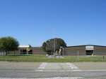
Below is the plat for Township 8, Range 3 West (top) and Township 9, Range 3 West in 1876 (bottom) -- (only Sections 39 and 3 through 6 of T9 R3 are in the Hathaway area). To get your bearings, Hathaway High School is located in Section 16 of the plat on top. (You can see the writing a little better if you "Zoom" your browser to 150%.)
Note the small lots that run vertically between the square sections and the swamp sections. When they were originally platted, these lots belonged to the government and were eventually sold one-by-one. When they drew the road, they used this route because of the public land and because there was a trail that led from Jennings that people and built homes along. This is the route that Highway 102 follows. Ever wonder why there was an S-curve on Highway 102? Look at the border of Section 41 (the last full swamp section on the top plat).


Section 38
Robert Rogers
Section 39
Joseph Francois Alexandre DeClouet who served both France and Spain in Louisiana for nearly 50 years
Section 40
Louis Chacere came from France via Natchez and Opelousas to escape the French Revolution.

Claim: Spanish grant, Feb. 21, 1785; U.S. claim, June 12, 1812.
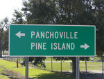
Geographical Description: Louis Chachere’s claim stretched across Bayou Nezpique. On the western side of Bayou Nezpique, the claim covered Section 40 of Township 8 South, Range 3 West, which today is most of Panchoville. The southern border on the western side of the claim angled south/southeast from where Ponderosa Road is today to Bayou Nezpique. The northern border runs slightly north of and parallel to Theo Road. The western border was along where Panchoville Road would be built.
 The tree line was narrow on the south, expanding west/northwest toward the center of the eastern border (about where LeJeune Road intersects with Panchoville Road) to a point just east of the northwest point of the property, then forming a cove to the east, leaving a narrow line of trees along Bayou Nezpique.
Original markers for claim on the western side of Bayou Nezpique were – A) Post marked D & LC; B) Small Hickory marked D & LC; C) Water Oak tree marked LC & CL; D) Post marked LC & CL. Surveyed by William Jackson on October 24, 1810. Chain carriers were James Ashworth and Jefse (sp?) Ashworth.
Section 41
Celestin Lavergne was a wealthy man from France.
 Claim: Spanish grant, __________; U.S. claim, June 24, 1812).
Size of claim: The claim was 40 arpents (116 chains, 36 links) along the banks of Bayou Nezpique and on each side, making it 3500 square arpents or 2761 acres.
Geographical Description: Celestine Lavergne’s claim covered Section 41 of Township 8 South, Range 3 West. In present terms as it relates to Hathaway, the claim covered the east side of Highway 102 from about Ponderosa Road on the northern border to where Highway 102 crosses over the gully at the southern end of the curve. The southern border then angles south/southeast toward Bayou Nezpique close to where Hines Road ends. The tree line covered about one-third of the claim along both sides of Bayou Nezpique. Prairie covered the other two-thirds of the claim, mostly on the western side of Bayou Nezpique. The tree line formed no coves on the western side. A small creek branched off of Bayou Nezpique along the southern border of the claim meandering in a westerly direction.
Original markers on the western side of Bayou Nezpique were – A) Post marked D & LC; B) Spanish Oak tree marked LC & CL; C) Cypress Tree marked X; D) A post marked CL. Surveyed by William Jackson on October 25, 1810. Chain carriers were James Ashworth and Jefse (sp?) Ashworth.
Section 42
Chief Le Tortue, Attakapa Indian Chief
An Attakapa Chief and his son, Celestine and Le Tortue, lived in a village on the west bank of Bayou Nezpique as the late 18th Century. The village was named Nezpique after an Attakapa Indian with a scarred nose (“nez” means nose; “pique” means pricked or tatooed). Tatooing streaks down the face was customary among the Attakapa. Tatoos were applied by pricking the skin until it bled, then fine charcoal was applied. Mixing the fine substance with the blood stained the skin below the surface, but the needle work was gruesome to their appearance.
The Attakapa in the village at that time totaled less than one hundred. This was down from two thousand five hundred total in Southwestern Louisiana at their peak. They were called Attakapa, meaning “man-eater” by the Choctaw. They called themselves “Ishak,” meaning “peaceful.” Whether the bands of Attakapa that lived in the Hathaway area were cannibalistic is uncertain. Archeological evidence suggests that the Attakapa were primitive, nomadic, and cannibalistic for many years, but oral history indicates they were peaceful, settled, and bartering by the late-18th Century.
About the time the United States made the Louisiana purchase, the Attakapa were selling their land. In 1791, Le Tortue sold 2,733 acres on the prairie west of Bayou Nezpique to William Wikoff for ten cows and calfs.
William Wikoff
A Notice of Claim was filed by William Wikoff on February 24, 1806. The notice read--
William Wikoff of the County of Opelousas claims Two thousand, seven hundred, and thirty three acres and 5/100 of land, situate on the Bayou or River Nepica [sic] in the said County: by virtue of a concession made by sale, and a valuable consideration paid in full to the claimants (two Indian Chiefs) being their Village, allowed them by Government, and ancient usage. The Sale and payment made, approved, and confirmed, by Nicholas Forestall, Commondant civil, and military, and Commander in chief, in the service of his Catholic Majesty in the Post of Opelousas; bearing date April 27th 1791.
Which Land was settled immediately after purchased, and is settled at this time. The grant and plot of survey for the Land contained there in, accompany this Notice, and adduced in support thereof. Given under my hand this 24th Day of February 1806.
William Wikoff

In 1798, William Wikoff received his Spanish land patent. By 1805, the Attakapa population had dwindled to less than 50. In 1814, Wikoff made a claim as owner of that land with the United States government. William Darby called him “the wealthiest stockholder in the United States.” It was likely the success of Wikoff that called Darby to predict that the main hope for the region was pastoral and that agricultural success would be limited to rice culture.
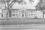
Below is an aerial photo from the U.S. Geological Survey in 1971 of the Hathaway prairies completely settled. To get your bearings, click on the link below. Look for the Grand Canal that comes from Bayou Nezpique in the top right corner. The canal comes out past Highway 102, then turns north. The canal then makes the shape of a barn (after a windstorm). Following the canal, you will see the canal cut across the southeast corner of a section. This is Section 16 and the land inside that small triangle on the corner is the campus of Hathaway High School.

To view a larger version of this photo, click to:
http://edcsns17.cr.usgs.gov/browse/aircraft/phoenix/afi/fullres/cass33/330419.jpg
then click on the image.
[[The Plats above for T8 R3 and T9 R3 show the trails that ran through Hathaway. To a certain degree, the descriptions of the trails below are accurate. Further research on different periods is needed to determine if some of the inaccuracies based on the plats is because the descriptions below are from a different period.]]
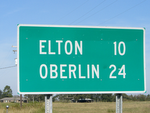
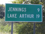
Before Jennings was settled, a stage coach ran from Andrus Cove, near Lake Arthur, to China, near Elton. Andrus Cove, one of the first settlements on the Mermentau River, was a settlement established around a sawmill that processed lumber coming down Bayou Nezpique to the Mermentau River, on its way to the Gulf of Mexico from the forests north of Elton. Although the soggy terrain prevented wagons to move lumber easily overland, that did not stop stage coaches. From the 1870’s through the turn of the 20th Century, a stage coach run by Frozien Roy ran from Andrus Cove to Elton. There was also a stage coach from Welsh that crossed the trail to Elton on it’s way to Opelousas. The stage coaches ran across trails over the Grand Marais and converged on the Simeon Gary store, located on the Grand Marais near Live Oak Cemetery (now Doucet Cemetery). If you look on the plat for Township 9, Range 3 West, above, section 6 and Township 8, Range 3 West, above, section 31. you can see all the trails converging on Simeon Gary's store. In addition to a store and cemetery, the Grand Marais settlement also had school, a blacksmith, a dance hall, and a rice mill.
 The main trail from Welsh was the first trail across the prairies of Hathaway. This east-west trail was made by Indians. Traders, travelers, and cattlemen used these same routes during the Spanish colonial period, to get to and from Opelousas to the Spanish missions in Texas. The main trail followed the same route Highway 90 and then Interstate 10 follow today. The main trail branched north at about where Lacassine is today, then north of Welsh, across a few miles farther north of Roanoke, then bending toward Raymond, crossing the Grand Marais bayou and curving hard just north of Raymond. A lone pine that towered high on the prairie served as a landmark for people headed east-northeast toward Bayou Nezpique in the direction of Panchoville at Vitterbeaux Crossing.
 The first north-south trail (on land) through the Hathaway area went from Mermentau along nearly the same route Highway 102 runs today. At the spot where Highway 102 meets Panchoville Road today, the trail curved slowly westward to a point just north of Old Relift #16, close to Crochet and Ringuet roads are today and then toward Elton. Many homesteaders built their houses near the trail. There were also many smaller trails coming off the main trail. The trails headed east off the trail lead to Bayou Nezpique. The trails headed west off the trail lead to the homesteaders to the west and another north-south trail that ran from Jennings to Elton, traversing the Grand Marais. Much of that land was difficult to pass because it was swampy in many places. Farmers have since tamed the Grand Marais. Many of the trails became roads. The names of these roads, which became official in the 1990's for emergency services purposes, demonstrates the interesting mix of Acadians migrating from the East and Mid-Westerners migrating from the north.
Every road branching off of Panchoville Road mirrors the arpent system of land grants. Nearly every road has a name of French origin and is named for family that lived off the road: Bertrand Road, Duhon Road, Babineaux Road, Comeaux Road, Demary Road, Crochet Road, LeJuene Road. An arpent measures 192 feet. The arpent system allowed grantees eight arpents (1,536 feet) along a stream or river and forty arpents (7,680 feet) away from the stream or river. This allowed grantees easy access to riverfront property as well as enough property for livestock, cultivation, and habitation. This system is still evident when turning off of Panchoville Road toward Bayou Nezpique--bring a compass along and turn off of Panchoville Road onto Theo Road.
The lines drawn by the rectangular square-mile surveying system is evident beginning at Highway 102 moving westward. The names of the roads on the plains away from the bayou, which were drawn according to the Americanized Public Land Survey System, reflect the names of those arriving from the north. The main roads running east-west include Tupper Road (northern most), Bucklin Road, Litteral Road, Lantz Road, Bryan Road, and Koll Road (southern most). Roads running north-south include Edmund Walker Road (north of Highway 102) and Compton Road (south of Highway 102). Mixed in among the roads on the plains are roads with names of French origin, like Grand Marais, which runs parallel to Koll road a mile north; Dama Landry Road, which runs south of Highway 395 North; Ardoin Road, which runs east-west, parallel between Highway 102 and Bryan Road.
No comments:
Post a Comment