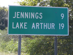
If the question "Where's Hathaway?" is being asked outside of Southwestern Louisiana, the answer probably includes Jennings or Elton, and is probably never a one word answer. The question that follows might be: “Where’s Jennings?” To which the response might be: “Oh, it’s a little town on I-10 almost mid-way between Lake Charles and Lafayette.”

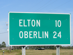
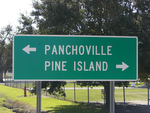
Hathaway is a rural community located at the intersection of Highway 26 (Elton Hwy, running north-south), which has a yellow-blinking light, and Highway 102 (Pine Island Hwy, running east-west), which has a red-blinking light. The people who call Hathaway home live in Ward 3 of Jefferson Davis Parish, Louisiana, which is bordered by districts serving Jennings to the south, Roanoke to the southwest, Fenton to the west, Elton to the north, Basile to the northeast, and rural Acadia Parish to the east. Bayou Nezpique makes the entire eastern boundary of the Hathaway area and separates Hathaway from Acadia Parish.

More specifically, Hathaway is located at:
Longitude: 92° 40' 17'' West
Latitude: 30° 20' 45'' North
orT8S R3W (all);
T8S R4W (sections 1-3, 10-15, 22-27, 34-36);
T9S R3W (sections 1-6).
T8S R4W (sections 1-3, 10-15, 22-27, 34-36);
T9S R3W (sections 1-6).
No comments:
Post a Comment